|
|
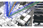
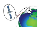
Maintaining reliable connectivity beyond the limits of terrestrial 5G is essential. This presentation shows how Wireless InSite ray-tracing software can accurately model and overcome coverage gaps by integrating low Earth orbit (LEO) satellite links with existing NB-IoT networks. |
|
|
|
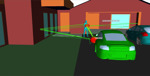
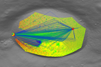
Wireless InSite 4.0 simulates dynamic RF environments, modeling moving transceivers, on-body propagation, lunar terrain, and time-based outputs, enabling accurate design and analysis for next-generation wireless systems. |
|
|
|
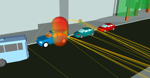
Human radar modeling enables advanced sensing applications, validated with NIST data. This approach demonstrates real-world use cases, including child presence detection and indoor monitoring, improving safety, accuracy, and reliability in complex environments. |
|
|
|
In rural areas, maintaining IoT connectivity is challenging. This article explores leveraging LEO satellites to enhance NB-IoT coverage, overcoming infrastructure gaps and extending reliable service beyond traditional terrestrial networks. |
|
|
|
Wireless InSite allows engineers to simulate time-based mobility, lunar propagation, and wideband ray-tracing, supporting analysis of moving devices, vehicles, radar coverage, and lunar RF communication systems. |
|
|
|
|